Wednesday, July 31, 2013

Speedgoat 50K: By Scott Wesemann


I have always wanted to run the Speedgoat 50K, so when several of my running buddies signed up earlier in the year I joined in and figured it would be a great tune up for the Wasatch 100. I can say that Speedgoat has not been my focus at all this year, but it was always there in the back of my mind and last week Craig and I were talking about how this race just kind of crept up on us and I can say that I was not physically or mentally prepared going in. My knee has been bothering me for a few weeks after having a run in with a large boulder on a summit ridge in the Uintas and it meant that my training has really suffered. I also had a stressful week with work, coaching soccer and family issues and I ended up getting just a couple hours of sleep the night before. I have never felt this unprepared going into a race and I thought there was a good chance I would have to take a DNF at some point. My goal was to get up to Hidden Peak and assess the knee and how I was feeling and go from there.

We arrived at Snowbird to sign in and rubbed shoulders with the local cast of ultra characters. These are great people and I always love getting to chat and laugh with them before a race. Along with the usual local cronies there was also a large contingent of ultra elites from around the world and one thing I love about ultras is that from the top on down everyone is just really cool and mellow and there are very few elite attitudes in the group.


After a few words from Karl Meltzer, the race director we were off running up the hill on our way to Hidden Peak. Almost from the start my knee hurt, but it wasn’t that bad and I knew I could deal with a little pain. I just hoped it didn’t get any worse. I ran with Matt Williams for a while, but he wasn’t feeling great, so I put some Oingo Boingo on my iPod and started grinding up to Hidden Peak. Other than the knee pain I felt fantastic. I didn’t’ want to push too hard because I knew there was going to be a lot of climbing and I wanted to save my legs.

It was a pretty good climb to Hidden Peak where Zac Marion and Kendall Wimmer were both there waiting to fill my bottles and get me what I needed. I had a few pieces of watermelon and some water and I was out of there. I was feeling really good and so far the knee pain was tolerable, but over the next several miles it would get worse with the steep downhill run to Larry’s Hole. I figured out pretty quickly that the down hills were painful and the ups didn’t bother me at all. My pace was slower than normal, but I felt great running into the Larry’s Hole aid station where I was greeted by more running friends. I didn’t even stop and just gave a few fives and obscene gestures as I ran through. My aid stops were very efficient all day long and I was able to run right through at least half of them.


On the way up to Hidden Peak
The run down to the mine was downright ugly for me. The trail was steep at times and where it wasn’t steep it was a rocky mess or quite often both. I never did get going fast. I passed Matt Van Horn and Craig about a half mile from the turnaround at Pacific Mine on their way back up and neither one of them looked great. I slapped some butts and sent them on their way. At the turnaround I drank some Coke and refilled my gel flask and then headed back up on what would be the worst climb of the day. It was about 7 miles back up to Mt. Baldy and those were some tough miles. I put on some Motley Crue and within a few minutes I was playing air guitar and singing out loud. I passed a few guys and was feeling great. The scenery in this section was just mind blowing with aspen forest, green meadows and lush pine trees. Incredible.

I was in and out of Larry’s Hole and not looking forward to the 2200 feet of climbing up to Baldy, so I got into grind mode and went for it. On the steepest part of the climb I broke out more air guitar and drums and cranked up the Crue. Awesome. I finally hit the summit and took a quick second to take in the incredible views and then ran the rocky ridge slowly back down to the aid stop below Hidden Peak. I pounded some more watermelon, refilled the gel flask and took off through the tunnel. I knew we were going to descend and have to climb back up to Hidden Peak, but I didn’t think it was going to be as far down as it was. I started muttering 4 letter words and thinking about all of the expletives I wanted to call Karl at the finish. The climb back up to Hidden Peak was simply brutal.

At the top of the peak I took more watermelon and a few jokes from Jim Skaggs and started the painful descent to the finish. Everything was still feeling great, but the knee was hurting and I knew the steep grade was going to hurt and it did. I was slower than I wanted through the talus field, but once I got onto more runnable terrain I thought there was some hope for a sub-eight finish and I pushed it hard for over two miles until I realized it wasn’t going to happen. I still finished strong and did have a few words for Karl. I thought the course was brilliant. Incredible. Fun. Hard. Course records were broken and PRs seemed to be had by many. This really is a world class race and one I will definitely be back to run again. Once again the Altra Lone Peaks were simply amazing. After running through some gnarly terrain for 31.5 miles I had zero blisters and my feet felt fantastic.


Sunday, July 28, 2013

Speedgoat 50k Grattitude

by Craig

I ran the Speedgoat 50k in the Wasatch Mountains of Utah yesterday. This race, hosted by Karl Meltzer is undoubtedly the toughest 50k in the country. With 11,000 ft of vertical gain and terrain as tough and rugged as it gets even the elites have been known to have tough days. As this was my first Speedgoat I didn't really know what to expect. I've run many of the trails and tagged all of the peaks along the course, but hadn't run many sections and wasn't sure how it would all pan out. The end result was that, once again, I had a horrible race and while my time was respectable, I was in no way happy with my own personal effort. And because I don't want this to be a negative article, I'll just leave it at that.


Even with all of my difficulties I had a hard time not enjoying myself. Three things were so evident throughout my race that I couldn't help but walk away with a heart full of gratitude. I've addressed each below:

1. The Course - Many of the competitors got so caught up in the rugged and steepness of the course that they were too miserable to take a few seconds to stop and look around. And while I was lost deep in the pain cave myself, I found myself often looking around at the amazing beauty that surrounded me. Add an overcast and slightly drizzly day and conditions couldn't have been better. There were moments when it was absolutely stunning. Meltzer has put together an incredible course and I loved being out in the mountains all day.
From the top of Mt Baldy, looking East

2. Volunteers - Generally after every race I rave about the volunteers. However, Speedgoat was a little different. You couldn't come into an aid station without someone meeting you well out front asking if you needed to refill bottles and what food to eat. You never left without being provided exactly what you needed to move onto the next stop. It was incredible. To make it even better for me, I knew people at every single aid station along the course, a perk of racing in my own backyard. Their spirit and support is what got me through that race and I will be ever grateful to them for it.

3. Recognition - I had something happen to me yesterday that I've never experienced before. Many times along the course I was encouraged, by name. I would look up, thinking I was seeing a friend, only to see a face I didn't recognize. I can only imagine that these people knew me through social media and this blog. But to be recognized and uplifted through their personal encouragement was a game changer. Additionally, I had several racers call me by name and introduce themselves. I will be ever thankful for the community that is ultra running and the relationships I continue to build. Thank you.

The Speedgoat 50k is definitely hard. Much harder than I thought it would be. Maybe that had something to do with my poor raceday, I won't know till I run it again and feel better about my performance. However, nothing will change the splendor of the race and how amazing the experience was for me.

Thanks to my amazing sponsors who continue to support me. I hope that soon my results, and not just my posts, reflect my appreciation in the trust they've put in me.
Altra Zero Drop Shoes
Gnarly Nutrion
Ultraspire


Monday, July 15, 2013

My Search for 13,000

by Craig

It is difficult to write a report of a failed adventure, especially one that has been so long in the planning. Not only am I faced with the difficulty of publicly reporting my failure, but I am equally tasked with reporting back to my sponsors that I didn’t live up to my end of the agreement (at least from a ‘mission successful’ standpoint). I’m hoping that through my writing they will feel they have received the due credit and exposure equal to the investment in myself and my partners. 

You might be asking yourselves ‘why 13,000 ft peaks?’ Well, the answer to that can be found in Part 1 of this report. In 2004, one year following my publicly reported Triple Crown (climbing Utah’s 3 tallest peaks in a day) achievement, along with good friend Scott Wesemann, we attempted a hair-brained idea to summit all of Utah’s 13,000 ft peaks in a single trip. While we were allowing for up to 5 days to complete the daunting task, we didn’t even make it out of the second day without Scott becoming severely altitude sick and having to cut our trip short after only two summits (I went on to complete three more). I couldn’t have guessed that nine years later (and after literally dozens of successful adventures with Scott) that what led to our failure in 2004 would be the exact cause for our failure this year.

That early attempt was done with little to no research and I had only been on three of the peaks previously. This year I had spent a great deal more time doing internet research, looking at photos, reading route descriptions, and emailing “Uinta veterans”. But with all my clickety-clack on the computer, I still hadn’t put in any more real work to get to personally know the rest of the peaks. Until this trip I had still only done 8 of the 21 peaks above 13,000 ft. I had assumed going into this year’s attempt that my research and skill on technical terrain would be enough to prove successful on whatever challenges were thrown at me. And maybe it would have had things gone differently with Scott. But I’m getting ahead of myself.

Just before we started
This attempt would still involve me and Scott, but we also invited Matt Van Horn, a respectable peak-bagger and wicked-good ultra runner. He would be a solid addition. We were decked out in Altra Lone Peak 1.5s and Ultraspire Fastpacks, which would be absolutely necessary. We started our adventure on the west end of the 13ers, but still in the relative middle of the Uinta range at the Middle Fork of Blacks Fork. We couldn’t get our car all the way into the trailhead due to poor road conditions and therefore had to start our journey a mile and a half early.  The first 9.5 miles were fairly uneventful. The trail meanders through a low valley at 9,000 ft and often disappears threw meadows. Scott slipped on a rock at our first main stream crossing and back-flopped into the water. The good partner I am I caught it all on film. More interesting were the number of cabin ruins we came across at mile 5. It’s not unheard of to come across old cabin remains in the back country, but to see this many was strange. We counted at least 10 within a tenth of a mile. 

 Looking up at Tokewanna
At the base of Mt Tokewanna, just before heading up the northern aspect we spooked a large herd of elk which was spectacular. The peak itself is 13,165 ft and we had more than a 2,300 ft climb to the top. The ascent was very straight forward and we moved quickly. Well, until we got above 12,000 ft, that is. Matt and I soon found ourselves alone and forcing ourselves to slow down so Scott could keep up. As he approached he mentioned he could feel the negative effects of altitude. We hoped that it would pass because we’d been in this spot before and knew if it didn’t our trip would be over almost before it began. Matt and I beat Scott to the summit by 20 min and were already discussing options when he arrived. We forced him to eat a substantial amount of calories and looked to the south at our route to Nortwest Wasatch. It wasn’t anything like what the map showed; rocky, thin, and exposed. It would require significant scrambling and now the sun was setting. 
 MVH approaching the summit of Tokewanna

 Our route: NW Wasatch (center), Wasatch (left of center), Lovenia (far left)
We stayed only long enough to get on some cold weather clothes and started down the south ridge. Matt and I were in good spirits, but Scott was still struggling. At the saddle, about 12,500 ft the calories kicked in and Scott finally started feeling better. We weren’t moving fast, but I was starting to think we might be able to pull most, if not all of this off. But once through the technical ridge and up the easy slope to the summit he hit the altitude wall again and slowed to a crawl. As he approached the summit Matt and I had already made the decision to abort the attempt. When Scott arrived we told him our plans, to which he argued and suggested he go out alone, but we had committed long before the start that no man would be left out there alone. We’d press on over Wasatch peak and down to Red Knob Pass and make a decision from there.
It was now well after dark and all of our navigation would be done by map and GPS. We were hoping for an easy cruise along the ridge, but what we thought would be easy was instead gripping. The ridge was incredibly exposed on both sides; one steeply angling to the west, the other a sheer drop to the east. MVH threw a medium sized boulder over the edge and we could hear it careening down the cliffs for over 45 seconds before it stopped. One wrong move and that would be one of us. In Scott’s condition things were now getting a little scary. This type of scrambling went on for about a mile before we finally approached the summit of Wasatch, 13,156 ft. Scott was still a bit behind even though we had waited on several occasions. When he did finally get to the top he looked worse than I had ever seen him (and I’ve seen him at his absolute worst). While he wouldn’t have admitted this at the time, I felt like we were in ‘rescue’ mode and our total focus turned towards getting him down the mountain to Red Knob Pass.

Once again, according to the map and route descriptions it appeared the route down to the pass would be fairly casual. We knew there were a couple of small cliff bands, but nothing too difficult. Maybe it was because it was dark and route finding more difficult, but that was one of the most difficult mountain descents I’ve ever made. Two cliff bands involved significant 4th class climbing down a face to loose dirt and scree. We then had to traverse under a cliff band on very sandy terrain, the result of a misstep ending in a series of cartwheels down a 1,000 ft chute. My eye was always on Scott. I’m sure he felt my nervousness was more of a hindrance than a help, but that’s how I generally am; I worry more about the people I’m with than myself. Gratefully, we made it to the saddle without any major incident and now had easy moving ahead of us.

We had all taken enough time off of work to complete the full 13ers, so why not take the long route out of the Uintas. Instead of taking the East Fork of Blacks Fork, we instead headed west along the Highline Trail. Having a GPS is pretty much mandatory out there as the trail fades in and out of long meadows. Cairns (piles of rocks) will lead you the appropriate way, but they can be hard to spot in the dark. At one point, just after Red Knob Pass we got on the wrong side of a snow field and started heading down into the wrong drainage before realizing our error and back-tracking back up. When we finally started down towards Dead Horse Lake we were only 15 miles in and it had taken us more than 11 hours. We stopped to refill and purify water about a mile before the lake. It was almost 5am. I was still very much awake (not sure why), but Matt was getting sleepy and Scott’s body still hadn’t recovered from altitude (we were still above 11,000 ft). We decided to take a nap above the lake and just before heading up the pass on a grassy slope. We pulled out our emergency SOL bivy sacks and crashed for almost an hour and a half. It was still dark when we lay down. We awoke to one of the most awe-inspiring sights I’ve ever seen. Dead Horse Lake and its drainage is one of the most beautiful places I’ve ever been in the state. Our lingering to get our things together simply allowed me to take in the splendor of my surroundings and cache a memory I plan to revisit in my head for the rest of my life.  

The climb to Dead Horse Pass looks far daunting than it really is. The trail switches back and forth easily up the steep incline, allowing for plenty of time to take in the last views before dropping over to the other side. Once over and into Rocky Basin the trail takes a near direct westward route over to Rocky Sea Pass. It looked really far away. As it turned out, it was. The trail is rugged through much of the section, but still plenty runnable and we made fairly decent time. I was feeling amazing and was moving fast. We found ourselves on the top of Rocky Sea Pass talking to some boy scouts almost exactly 4 hours since leaving Dead Horse Lake. One of the leaders informed us we had about 9 miles to go. Luckily, the trail to Mirror Lake was a net loss. 

 Looking down at Dead Horse Lake from the pass
We started down. The farther we got the hotter it got. And while it was a net loss to the finish, there were still plenty of climbs to frustrate us. The trail was also rockier in this last section than at any point until then. Boulders were strewn throughout the trail, making it nearly impossible to maintain any kind of consistent running pace. Scott was beaten down and relegated to walking the last four miles. I sent MVH ahead to make sure we had a ride out, so it came down to Scott and I. We were low on water, he was wrecked, and I was just anxious to get out and see my wife and kids. When we hit the campground and hiked through it we got to our ride at almost exactly 24 hours after starting. Matt and Josh were there to meet us with cold Pepsis, chips, and licorice. 
 Heading down into Rocky Basin
Now, a few days later, it is difficult to look back and feel the pang of failure when it came to attempting my dream. But it was an incredible outing and I loved all of the other parts of the trip I wouldn’t have experienced had we kept going. I also learned several things about the route. It will be epicly hard. Much harder than I had planned. Can it be done at all? Absolutely. Can it be done by me? Definitely. Will I be the first person to do it? I don’t know. What I am certain of is that I need to climb at least the peaks in the middle section before attempting it again (I know exactly what to expect on the final Kings/Emmons ridge). Therefore I may not be able to try it next year as I will have to focus on getting to know the route better. For anyone reading this, the gauntlet has been thrown. Do it if you can. If not, I will return and this time, victorious.
It’s important to recognize our sponsors and site a lot of the gear we took.
Ultraspire – we used the Fastpack. This 19L pack can do it all and is insanely comfy. I had way too much gear and food and still had a ton of room. I would recommend this pack for anything that requires a significant amount of gear.
Altra Zero Drop Footwear – The Lone Peak took on the rocks and trails like it was nothing. We crossed a bunch of rivers and our shoes were dry within a couple of hours.
H2Go Water Purifier – Without this water purifier I’d be sicker than a dog right now.
Gnarly Nutrition – I used the Boost electrolyte water additive and wow, it made such a huge difference.
Other gear included: SkyCall Satellite phone, Garmin GPS, SPOT tracker, Sony Action Cam, GoPro, DryMax socks, SOL emergency double bivy, VFuel and Hammer energy gels, and literally way more food than I could have eaten in three days.

Wednesday, July 3, 2013

My Wasatch Adventure: The Millwood 100

by MVH

Three weeks ago I was driving down Big Cottonwood canyon after a refreshing run up to Gobbler's Knob and Mt. Raymond.  It was one of my first post-Winter visits to Big Cottonwood trails this year and I was in love with the idea of coming back, day after day through the Summer. Then I remembered the MillWood 100, and that at the beginning of the year I had listed it as one of my goals for 2013. I had forgotten about it but suddenly it became stuck in my thoughts and wouldn't come loose. I immediately phoned some friends and asked if they would be available to be support along the way. They responded enthusiastically and I set the date for 3 weeks from that point, then set out to familiarize myself with parts of the route that were unknown to me.

What is the MillWood 100? It is an invention of local mountain runner Jared Campbell, who looked at a map of the Central Wasatch and found a way to connect trails and off-trail routes to form a challenging 100 mile foot course. Jared's description: "The result is a route housed in Millcreek, Big, and Little Cottonwood and has about 45,000′ of vertical gain.  It has it all, everything from beautiful smooth singletrack, wicked steep abandoned mining trails, completely off-trail sections, less than 1 mile or road, and very little flat.  It has been “designed” so that it is easy to make water/food drops, crew, bail, and start or stop in many different locations."

Look:

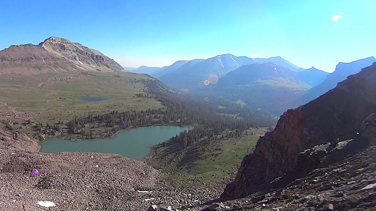
Millwood starts (red line) and ends on the blue balloons

July 2012 Erik Storheim became the first person to complete MillWood in one continuously long day, finishing in just under 39 hours. Later that year, Campbell became the second to finish in one long day, coming in under 35 hours. After training for, starting, then dropping out of the Bryce 100 in May, I had a massive store of unspent energy. I was all trained up with nowhere to go. The Bryce DNF stung, so MillWood was to be my consolation of sorts, a way for me to prove to myself that I could still endure a hundred miles. Plus, I love the Wasatch and the idea of taking a grand foot tour of my favorite place on Earth appealed to me.


Going into Millcreek at dawn (Scott Wesemann)

Friday morning June 28, at 3:12 am I began hiking up the Neff's canyon trail. Good friend Scott Wesemann accompanied me for this first segment up and over to Millcreek Canyon to connect with the Desolation trail, then a run down to Millcreek Canyon and the Pipeline/Church Fork junction. As we always do, Scott and I laughed a lot as we hiked up the trail in the darkness. He had never been up Neff's and was pleased with the view of the city lights twinkling in the pre-dawn below. I purposefully did not start out fast because of the distance and climbing ahead of me, but I was a little bugged about taking 3 hours to get down to Millcreek canyon. I was hoping to go faster.  However, as the day progressed and the heat grew, getting behind on my goal splits became the theme, and I had to embrace the fact that I would probably not finish this thing under 40 hours.

I said goodbye to Scott at the Grandeur trailhead at Church, and ran the Pipeline trail West from Church Fork to Bambi Hill, then around to the West side of Mt Grandeur. As I began the 3,000 foot ascent I met Nate Pack, who told me he had met Erik Storheim at the summit, and that Erik had left his light trekking poles up there for me. I gave my heavy poles to Nate and continued up. At Grandeur summit I grabbed Erik's poles and then ran down Church Fork to find my cache of water and food, and to apply liberal amounts of sunscreeen. My shirt was off at this point and temperature must have been in the 80s already at 9am. I ran to the Burch Hollow trail and then began a quick ascent up to the top of Burch Hollow, to the Millcreek Ridge. I had arrived at the section I most dreaded. The trail on Millcreek Ridge is horribly overgrown. In fact, there isn't much of a trail. I had been there a few weeks before but managed to get off course again. After a horrendous schwack back up to the ridgeline, I continued down to the saddle under Mt Aire, then ran down to Elbow fork. I had been communicating with Scott throughout the morning and he promised to meet me at the Bowman trailhead with lunch and cold soda. The promise of a cold Coke was motivation for me in the increasing heat. I showed up at Bowman overheated and tired, but willing to continue. Scott brought me a burger, fries, and the blessed cold drink.


With water re-filled and a run of cold water over my head, I continued up the Bowman trail toward my next desination of Gobblers Knob. A few trail runners ran up past me, including Dan Gardiner. Hey, I used to be a trail runner. Walking was the only gear I had. Looking back, I must have had some dehydration, and I carried on with that lack of energy all the way up to Gobbler's Knob in crawl speed. Jared Campbell met me as he came down from a run up to Gobbler's, and offered to run to his car and bring back his SPOT Tracker. I continued on uphill, and rested several times in the shade. I even tried to lay down several times but the damned flies wouln't let me rest. After Jared caught up and set up the SPOT, I felt much better and ran well on the connector trail to Alexander Basin. My spirit was good again, but then the big climb up to Gobbler's in the afternoon heat was a real challenge. Jared had told me there was meltwater near the top of Alexander Basin. I found it and filled up with cold, clean water.

The time was past 4pm when I reached the top of Gobbler's. A text from my wife came in and suddenly I missed her and my boys greatly. I was a physical and emotional wreck. A call from Scott helped me move along down to Baker Pass and onto the desolation trail toward Dog Lake. I moved well through to Dog Lake, then down to Big Water at the top of Millcreek Canyon. I had stashed a Pepsi and two bottles of water under a rock in the creek and went straight for them. It was 6:45 pm by the time I departed Big Water. The exertion in the heat of the day (over 100 degrees in SLC) had left me nearly spent, so it was a walk up to the Great Western Trail to the ridge line between Salt Lake and Summit (Park City) Counties. Upon reaching GWT, the sun had become obscured behind clouds and I had cooled enough to begin running uphill. My energy was back and I ran the entire GWT to Beartrap Fork, then down to Big Cottonwood Canyon.
Applying glide spray, a new experience for me
(Josh Greenwell)

At the canyon road I found my food and water cache, mixed up a recovery drink, got my headlamp on --it was past 9 pm -- and replaced my cache.  I was at mile 48. Josh Greenwell showed up with a steaming pizza and Pepsi, which I gratefully accepted. Then Mark Kreuzer and Zac Marion met us. I was so happy to see those guys. Night had come, I was fed and cooled down, and feeling much better. Mark brought a quarter pound burger for me and I stashed it away for later. Mark and Zac were my companions for the Days Fork to Silver Fork section. We had a great time after walking through a wedding party looking for the trail head. We did some solid uphill running up Days, then hiked as the grade became steep. On the crossing into Silver Fork I found snow and helped myself to several mouthfuls. It was the best stuff.

snowcone (Mark Kreuzer)

From the top of Silver Fork we ran the majority down, moving very quickly once we got onto the smooth single track and then 4X4 trail to the cabins. We followed the road from the cabins too far and came out at the lower Solitude parking lot. Crap. That meant we had a nice mile run back to where I should have been. Extra credit! The next section of the route was a short loop up to Willow Lake then back to Solitude. Mark accompanied me while Zac got some rest at the car. When we arrived back at Solitude, my brother Peter and his wife were there with tacos and Coke for me. We talked for a time while I ate, then the other guys told me to get moving. Mark and I had not been on the Solitude/Brighton trail so we of course took a few wrong turns, but arrived at Silver lake eventually. Zac then took over and we said goodbye to Mark.

I remember the climb up to Twin Lakes being very slow. I had been going for over 24 hours at this point. Zac and I got to Twin Lakes pass at sunrise, then the slow hike continued as we moved uphill to Patsy Marley and Mt. Wolverine. My fatigue was obvious so Zac prescribed some powerful 80s music to act as a pick-me-up. It worked. The air drums and guitar came out. Warm sunshine washed away the morning blues.


Above Twin Lakes (photo by Zac Marion)

At Albion Basin, Zac said goodbye and I was alone on the hike up to Cecret Lake. Past the lake I saw a runner moving back downhill to me. It was Jim Milar, who was out with a couple friends on a nice morning run up to Hidden Peak. I hiked with them up to Baldy and down to the saddle under Hidden. I was grateful for the company. From the saddle I ran as best I could with very sore feet down to Alta. My brother Pete was waiting at Alta with some breakfast food. As I reached the homes at the end of the road at Alta I looked up to see Jared Campbell running up to meet me. He and Mindy had come up to help me get ready for the climb to Cardiff Pass. They had everything I needed: Chocolate milk, sunscreen, and smiles. I felt so good then that I ran the mile up the road to meet them and my brother at the trailhead to Cardiff.


The climb up to Cardiff Pass was slow due to 100 degree heat. Erik Storheim called and indicated he was up at the pass and would run dow to meet me. We hiked up together and descened into upper Cardiff. I had never been in upper Cardiff and even in my fatigued state made note to come back and explore the area more thouroughly. We descended on trail, then on mining road down to a large ore bin where some men were doing some actual mining. It was funny watching Erik stride right up to the men at the back of their truck and then continue up the road. Two groups of men in a remote area with vastly different purposes for being there. The men had sparkly rocks displayed on the truck tail gate.

Up and up and up. Erik led me off-trail across the slope under Kessler Peak. He had gone up earlier in the week and put up ribbons to guide us. He was proud to see that he led us right to them. We were on course. Then, we found the abandoned miners trail that leads straight up the mountain side. I was tired and hot but I had plenty of energy for the climb. It actually felt good to take downhill pressure off my toes. We summited Carbonate Pass, took a few mintes for a break, then began the descent down the West side of Kessler. We skied talus and crossed slanted slopes until we came to another rough abandoned trail. Then we found the log slide that goes straight down to Big Cottonwood highway. Erik and I had pleasant conversation and he told me interesting stories of his dental practice.
On the road between Kessler and Mineral Fork
(photo by Matt Williams)

Erik was a brilliant companion. He knew what I was experiencing because, well, he is one of only two others to do MillWood. Kessler was, I decided, brutal and the toughest climb and descent up to that point. I was half-dreading the climb up Mineral Fork. It was now, I guess, the hottest part of the day. Erik and I walked down the road in the heat. I was out of water, but felt good knowing Matt Williams was waiting at Mineral Fork to help me re-supply and make the next big climb. I sat in Matt's truck for about 20 minutes, drinking and eating, getting mentally prepared for the second-to-last big climb of MillWood.
Regrouping for Mineral Fork (Matt Williams)

I had another cache hidden at Mineral Fork, but since Matt showed up bearing all the goods of a supermarket with a coffee shop, I just left it. Matt kindly took it back to his car while I began the hike. I had hoped to regain strength for the climb up to the pass above Lake Blanche. Unfortunately, I never regained energy. It was a slow, plodding hike up the 4+ miles and 4,000 feet to the top of Mineral. Matt was patient as always while I took several sitting breaks. I wondered if I would have enough left in me to finish this thing.

photo by Matt Williams

When we reached the top of the pass I had just about had enough. Scott called and told me I was almost there, that friends were cheering me on, that I couldn't stop now. I agreed, but had to acknowledge that my condition needed to change if I was to get down past Blanche to Mill B trailhead, then make the final big climb up Mill B North to Mt Raymond. After some rest at the pass, Matt and I began a quick descent. I wanted to get to the lake in 1 half hour. I think we were close. Despite aching feet, we moved quickly to stay away from thirsty mosquitoes that had come out. On the descent Matt was feasting on the super natural scenery of Mill B East branch. We saw waterfalls, small lakes, cliffs, bulging slabs of reddish quartzite, green trees and steep sloping canyon sides covered with green vegetation. A paradise. On the Blanche trail we passed hikers coming up, some complaining about this or that. I looked back at Matt and smiled. Finally at the end of the trail, familiar faces came into view. Josh Greenwell, and Nick Sourlos with his wife and kids. His lovely little girl was ringing a cowbell. For me! So awesome. How could I not go on?
More cowbell? Naw. This one will do.
(photo by Nick Sourlos)

I made a long stop at Mill B trailhead. I needed it. I ate, drank, popped blisters, changed sock, and rested. The sun had gone down and I was cooling. About 10:15 pm Josh and I started uphill for a 4 mile 3,000 foot climb up to Desolation trail. I fetl terrific and we moved quickly. We chatted, sang to 80s butt rock tunes blasting from his portable speakers. It was a party I will never forget. One of the best times I've ever had. I was so confident of getting to the finish in half the estimated time that I texted Matt Williams and said we would cover the last 6 miles in an hour and a half. I was thinking we could blast the soft, pine needle-covered trail down into Millcreek. And we started out doing that. It was dark, cool, and I felt fantastic. Josh and I ran the trail as fast as if we were out for a normal night run. Neither of us had been on that particular part of the Desolation trail. We expected it to start heading down hill anytime. Anytime now. Please. Please? Nope. The trail wraps around minor sloping ridges, in and out of draws. Switchbacks. Then, it ended. Disappeared. We sat in the dark on the side of a slope under some cliffs. I wasn't about to go down and lose all that elevation we had. I called Scott. "We are lost." Then my phone battery was done. Josh did not have his. What to do? We sat for a good 25 minutes, then decided to back track. We found the continuation of the trail, hidden under a patch of snow. Back at it, but a little demoralized. Josh, you got anymore butt rock tunes? Guns N' Roses came back on, then Warrent's Cherry Pie. Then my favorite, RUSH. Air drums came back out. We were having fun again.

We sussessfully navigated to the Thayne Canyon trail, then, cursed the Thayne Canyon trail. Straight down, steep, and rocky. Nice way to end it, Jared! At last, at about 3:30am we stepped off the trail and I was finished. Mrs. Leslie Howlett was there to give us a woop! and Matt Williams with her. I still felt fantastic and wanted to drive home but the others treated me like a drunk. I wondered if punches would be thrown if I tried to drive home by myself. I had been moving for 48 hours and 26 minutes. All I wanted then was a chocolate milk. Matt obliged and drove me to 7-Eleven.


I know this sounds trite, but my Wasatch adventure changed me. I like the change. I feel a greater love for people around me. I value my friends more. My persective on...things... is a little wider. I went to my limit and discovered there was more on the other side. When I am asked, "Should I?" my answer will be...

Go For It.


photo by Zac Marion